Between 1960 and 1984, the United States operated a series of reconnaissance satellites that photographed the Soviet Union, China, and much of the rest of the world. The imagery was some of the most tightly classified material of the Cold War era. Most of it has since been declassified, and quite a lot of it is now on SpaceFromSpace.
The archive currently holds over 750 georeferenced historical satellite images, all free to explore. No account needed. Take a look!
The Programs
The collection draws from three main American reconnaissance satellite programs, CORONA, GAMBIT, and HEXAGON, covering roughly 25 years of Cold War photography. A dedicated article on these will be coming soon!
The Interactive Map
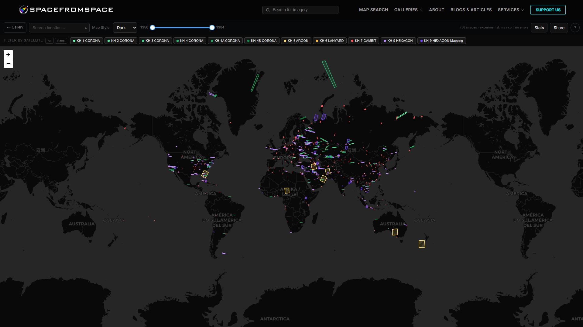
Every image in the collection is accessible through an interactive map on the site. You can filter by satellite program, browse by region, and click through to the full-resolution scene. The map makes it easy to find old satellite images of specific places without needing to know USGS EarthExplorer’s catalogue system or the mission designations of individual flights.
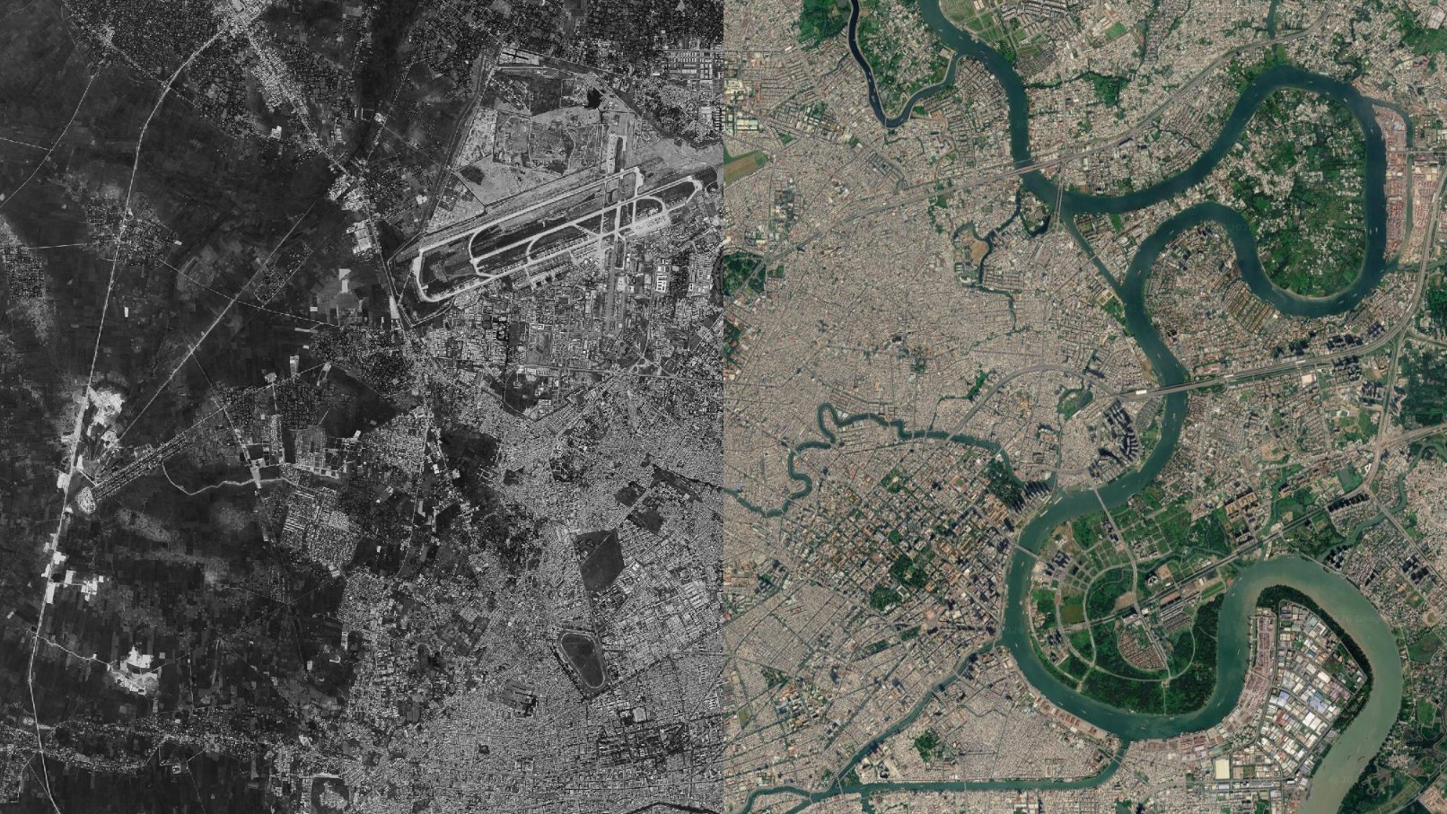
Each image is georeferenced to its real-world location, which means you can compare it directly against modern satellite imagery and see what’s changed. For some locations, that comparison is subtle. For others, it’s dramatic.
How the Imagery Gets Used
A good example of the archive being used for actual research is the work I’ve done with Dwayne Day, a space historian and contributing editor at The Space Review.
The Falklands War
KH-9 HEXAGON captured the Falkland Islands on May 31, 1982, and again on June 13. The Argentine surrender came on June 14. Those two frames cover the final weeks of the conflict, and they raise genuinely interesting questions about what American reconnaissance capabilities could see and what intelligence was shared with the British during the war.
Dwayne Day and I worked on an article for The Space Review using these images as the primary source material. Both full scenes are on SpaceFromSpace and free to browse. The article is at https://thespacereview.com/article/4886/1.
Cyprus, July 1974
The Turkish military landed on Cyprus on July 20, 1974. HEXAGON passed over on the same day, and again on July 24.
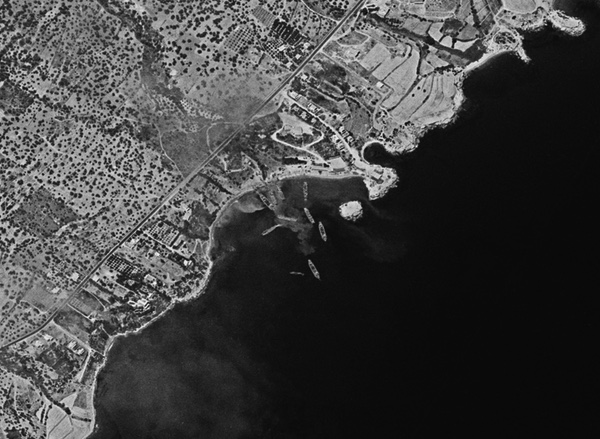
I’ve uploaded both scenes as full-resolution mosaics. The contrast between the two is striking. Four days apart, and the situation on the ground had already changed significantly. These have also come up in research with Dwayne Day as part of documenting what the satellite record shows for key Cold War events. See the article at https://thespacereview.com/article/5049/1
Some Other Scenes Worth Knowing About
The archive is broad enough that a few scenes stand out on their own:
Baikonur Cosmodrome, July 1972
The Soviet N1 Moon rocket is visible on the launch pad, two months before its fourth and final test failure. The N1 programme was cancelled quietly afterwards. Western intelligence had limited knowledge of it at the time.
Cape Canaveral, December 1968
Three frames from the same month Apollo 8 flew to the Moon. The launch complex is clearly visible from above — the radial flame trench pattern, the service roads, and what appears to be a Saturn V sitting on the pad.
Chernobyl, 1974 to 1984
Five pre-disaster images across a decade, from early construction through to two years before the explosion.
Aral Sea, 1960 onwards
KH-2 imagery of the Aral at full size, and then across the following decades as it started to shrink. The historical satellite images covering this period show the scale of the change clearly.
Lop Nur, October 20, 1964
Four days after China’s first nuclear test on October 16, 1964, a KH-4A CORONA passed over the test site. The detonation crater is clearly visible, showing a dark central depression with blast scarring radiating outward across the desert. Roads and tracks extend across the wider site. It’s one of the more fascinating frames in the archive.
What the Archive Is For
Primarily, it’s a resource. The imagery exists publicly through USGS, but navigating EarthExplorer isn’t straightforward, and the processed and georeferenced versions that SpaceFromSpace provides are easier to work with for research and comparison purposes.
If you’re looking for old satellite images of a specific place or event, the interactive map is the best place to start. If you’re a researcher working on something that might intersect with the collection, feel free to get in touch.
The collection is growing. There’s a lot of the archive still to process.
Browse the full collection at https://spacefromspace.com/declassified-satellite-images/ and interactive map at https://spacefromspace.com/declassified-map-search/.